Oct 3, 2012
Valbona Valley, 28 September 2012
The Valbona valley is dominated by high mountains which offer fantastic views and varying colorful, seasonal panoramas. The name "Valbona" comes from a small village in the valley.
Valbona Valley National Park is a national park in Albania declared by government decree in 1996. It covers an area of 8,000 hectares and is located along the Valbona Valley. A main attraction is the Valbona River flowing in the middle of the valley.
The Theth National Park is adjacent to it and was declared a national park in 1966. It is proposed that the two parks, along with the areas in Montenegro and Kosovo form a tri-border the Balkan Peace Park.
The Balkan Peace Park is a proposed park is located in the western part of Kosovo, north-eastern part of Albania and south-eastern part of Montenegro.The terrain is rugged and the park is home to the highest mountains in the Dinaric Alps including Maja Jezerce 2,694 m.
Autumn is approaching and the herders are driving the sheep’s down to their winter grazing.
View from our homestay
Our host at the small farm which had big business as a homestay and where we stayed
Our host with one of his sons (to the right) and our guide (to the left)
On a long stretches of the river is disappears between the stones on the river bed. Here it has just reappeared
After we had arrived we went up a Valley. The two elderly people from the nice little white house are working with their maize harvest.
Eurasian Jay Skovskade (Garrulus glandarius)
Valbona Valley does not offer landlines, internet connections, or mailing addresses. It is considered one of the most remote places left in Albania.
Lake Komani, 28 September 2012
Our little Danish group (Kurt,Birthe, Allan and I) and our guide, Naim Selimaj, gathered at 5 in the morning to take the minibus to Komani where the waterbus on the Komani lake starts.
Lake Komani was created in the 1970s—the by-product of a massive hydroelectric project. The narrow, twisting and turning body of water is edged by sheer cliffs that have been there for thousands of years. Travelers compare this part of the world to Norway and its fjords. The two-hour ride on the car ferry is one the nature highlights of Albania.
Pig or pit stop, two nice pigs next to the café where we had a coffee stop on the way
The Lake Koman bus-ferry
Passenger with a sack of apples leaving the ferry
Another passenger
Lake Koman taxi
Albanian family on board the water taxi
The minibus type
Our waterbus: Dragoba. Some clever locals had taken a public bus and built a ship's hull around it. This is the local waterbus service that that ply the long, sinuous waters of Lake Komani
Waterbus passengers – it is our guide to the left
Two Albanian boys
The scenery
Where there is some arable land there are also houses
We passed many impressive haystacks
Lake Komani is a dammed lake, running some forty kilometres through the heart of the Dinaric alps.
Ferrybus-stop: The people living on the shores of the lake, almost totally cut off from the world around them, rely on boats to get anywhere and on the ferry to bring them any supplies or mail.
Sep 19, 2012
Albania: From Valbona to Tirana via Lake Komani, 17 September 2012
We went up at 3 in the morning to take the small Ferry which departs from Fierza at 06:00 in the morning and arrives in Komani at 08:50
We took the local bus called Dragoba down the lake
Some clever locals had taken a public bus and built a ship's hull around it. This is the local waterbus service that that ply the long, sinuous waters of Lake Komani.
Previously there was to big car ferries operating on the lake. As of June 2012 the car ferry is no longer running. The new highway connecting the coast with Kukes and Kosovo has made it redundant.
But the small bus-boat is still running and full with passengers.
The passengers aboard the Dragoba were mostly going to or from home – we made a lot of stops at tiny landings, not much more than a few rocks, so that people could jump on board or ashore or collect packages.
Lake Komani is the result of the Drini River being dammed. The steep mountains and narrow valleys ensured that the new reservoir retained the narrow shape of a river rather than that of a wide lake.
Some times it looks like you are driving straight into the rocks
Lake Komani is a dammed lake, running some forty kilometers through the heart of the Dinaric alps.
As desolate as the lake seems, its shores are actually inhabited by a few hardy families. Clinging to the cliff-like sides of the mountains are tiny farms, not much more than hovels with a few square feet of plowed earth and a handful of goats.
These people, almost totally cut off from the world around them, rely on boats to get anywhere and on the ferry to bring them any supplies or mail.
From Komani we went with the minibus to Rozafa castle, a castle near the city of Shkodër, in northwestern Albania. It rises imposingly on a rocky hill, 130 metres above sea level, surrounded by the Buna and Drini rivers. Shkodër is the capital of the District of Shkodër, and is one of Albania's oldest and most historic towns, as well as an important cultural and economic centre.
Due to its strategic location, the hill has been settled since antiquity. It was an Illyrian stronghold until it was captured by the Romans in 167 BC. The fortifications, as they have been preserved to date, are mostly of Venetian origin. The castle has been the site of several famous sieges, including the siege of Shkodra by the Ottomans in 1478 and the siege of Shkodra by the Montenegrins in 1912
Swallowtail, Svalehale (Papilio machaon)
Bellflower, Klokkeblomst, Campanula
View over Lake Shkodra from the Rozafa castle, a massive lake just west of Shkodra, 60% of which is in Montenegro. Lake Shkodra is in fact a former sea bay that was cut off from the Adriatic when the sea levels dropped, thousands of years ago. The lake is the largest in the Balkans at 41km long and between 370-530 square kilometres, and the lake surface varies between 5 and 10 metres above sea level depending on the season (lowest in winter). As its depth is up to 60 metres, the bottom of the lake is well below sea level, making it a so-called cryptodepression.
We had our lunch in a nice restaurant just next to the Drini River. The restaurant had its own little zoo with local mammals and birds.
Lynx
Eagle
Drini River
Sep 18, 2012
Albania: Valbona, 16 September 2012
The second day in the Valbona Valley we went up the river bed to where the Valbona River starts.
The Valley are inhabited by three ethnic groups:
- In the upper part people from the nearest village to the west: Thethi (Orthodox Christians).
- In the middle part of the valley; Montenegrins (Orthodox Christians).
- In the lower part of the valley to the east: Kosovo Albanians (Muslim)
View from our bedroom window
The Valbona Valley. For agricultural purposes the land has been terraced
A house in the upper part of the valley. The steep roof probably reflects the need to avoid problems due to big amounts of snow.
A happy pig on its way to the grazing together with the cows
The very start of the river before it disappears between the stones
A farm
An eagle (?)
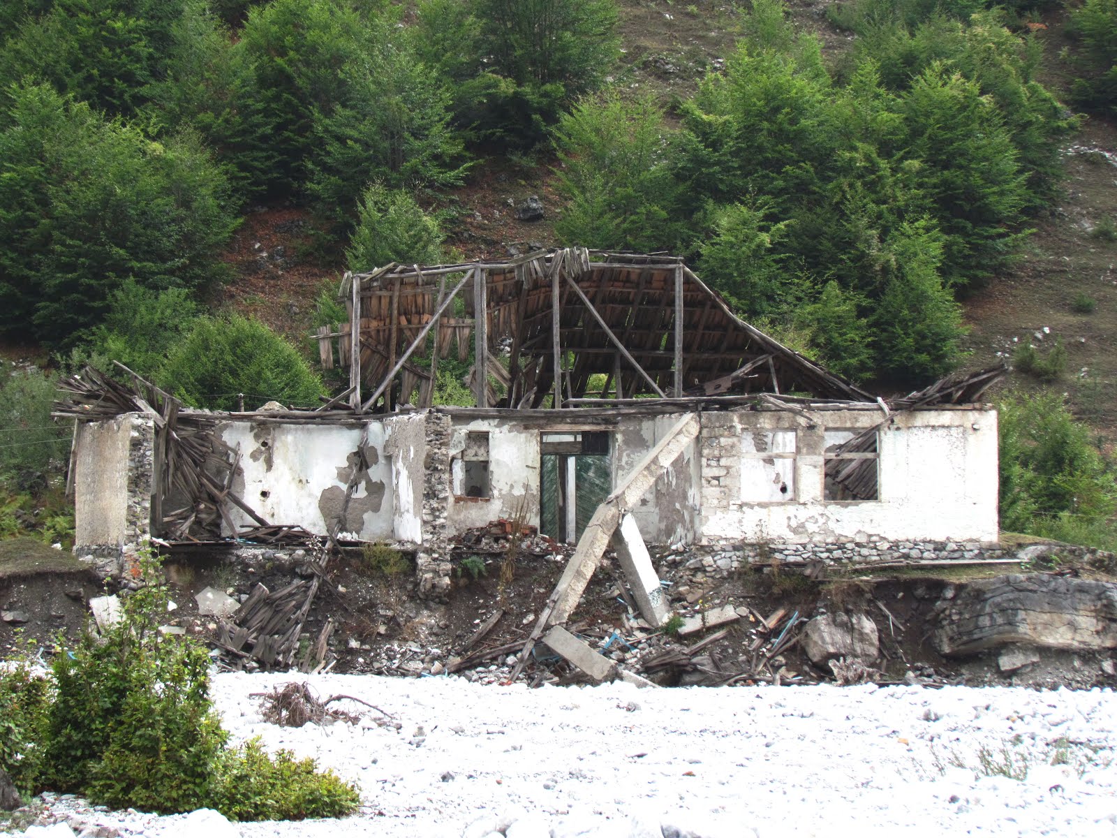
The ruins of the school where the brothers from the farm went when they were children. Parts of the building has been swept away by the river, so there must be water above the stones some times.
On our way back we had a cup of coffee at a nice new hotel is situated where the road ends and turns into a jeep track. The owner drives this impressive Toyota LandCruiser turbodiesel.
The hotel is situated at a spring. In communist times the place was popular among top communists (by then it was another building than the present).
The Toyota LandCruiser is a gift from Danida (Ministry of Foreign Affairs of Denmark)
In the late afternoon a group of 12 members of New Zealand tramping and mountaineering clubs came to the farm to stay overnight. They had crossed the mountain pass between Thethi and Valbona. In front the guides and the horses carrying their luggage.
Subscribe to:
Posts (Atom)